Traditionally the marine atlases were based on the visual reports taken from ships. On top of the unavoidable errors, these data carry with them a basic flaw, because of the care with which the captains try to avoid as far as possible the stormy areas. Besides these data are concentrated only on the main shipping lanes.
More recently, during the last 10-20 years, three new sources of data have become available: buoys, satellites and numerical models. However, notwithstanding the enormous increase of the volume of data, no single source satisfies the requirements for a reliable statistics throughout the area of interest. The limited number of buoys provide only local data, The data from satellites are available only in correspondence with their passes, typically at several day intervals. The model data may show some substantial approximations, like in the Mediterranean Sea, where the wind speeds and the wave heights are frequently underestimated.
The solution is to make use of all the three sources to obtain the best data-set of wind and wave data presently available in the Mediterranean Sea. The procedure goes along several steps. The buoy data have been used to validate the satellite data. Then these allow the calibration of the model data on the whole basin. Using both time and space interpolation, the wind and wave model data have been evaluated in correspondence of the various satellite passes. For each sea point, typically at 50 km intervals, this has made available a large number of corresponding couples of data, model and satellite. This has allowed, for each sea point, the estimate of the local correction coefficients, separately for wind and waves. Finally the coefficients have been used to calibrate the long time series available at each point from the models. The results have been verified comparing the buoy data with the corresponding calibrated model data.
The model data, originally from the archive of the European Centre for Medium-Range Weather Forecasts (ECMWF, Reading, U.K.), cover the period July 1992 - June 2002. The satellite data derive from ERS1-2 and Topex (wind speed and wave height). The eight buoys, part of the Italian wave buoy network, are moored all along the Italian peninsula.
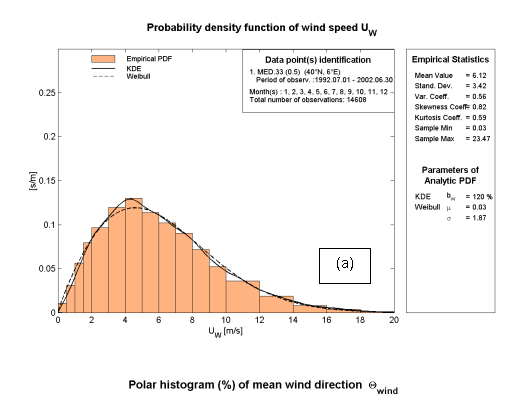
Given the ten years of data at disposal, extensive statistics have been obtained, concerning both the single points (e.g., the frequency distribution of the wave heights) and the overall basin (distributions of the extreme values, main flow directions, etc.). The overall results have been published as the wind and wave atlas, MEDATLAS, of the Mediterranean Sea, available in paper and electronic formats. The attached figures show the cover and some maps from the atlas.
MEDATLAS is the product of a joint effort from France (CS SI, Semantic, Meteo-France), Greece (NTUA) and Italy (Thetis, ISMAR-CNR), within a project funded by the French, Greek and Italian Military Navies through the WEAO Research Cell with contract RTP 10.10.
Vedi anche:
Immagini:


