The issues that confront scientists studying continental margins are complex and range from drainage basin dynamics to sediment transport theory, sea level history and climate change. Many of the scientific concepts employed to understand societal problems like coastal pollution, hydrocarbon and ground water reservoirs, landslide hazards, and coastal erosion are deeply rooted in understanding sediment transport and stratigraphic sequence evolution. Two overarching questions behind these complex issues are: how marine strata form on continental margins? and how strata stack into thicker depositional sequences? Enhancing our ability to solve such problems requires also a substantial advance in new investigation technologies (swath bathymetry, geophysical imaging of continental margin sequences, and long coring or drilling) and innovative modelling in large integrated programs. These studies are best conducted in areas where sediment flux from catchments is high and well monitored and oceanographic advection/diffusion is well studied. The Adriatic basin presents all these characteristics and was selected as the key study area by a large community of European and North-American stratigraphers, sedimentologists, oceanographers and modellers.
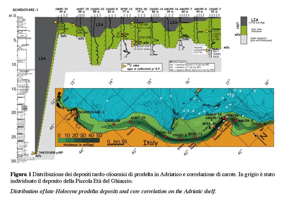
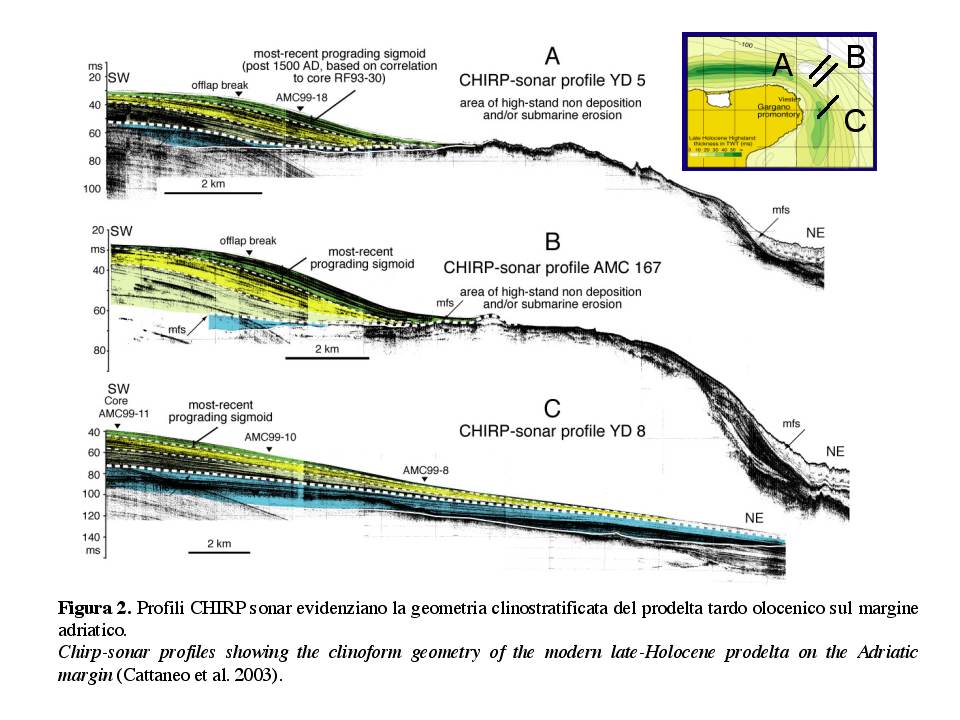
The actively-growing mud wedge on the western Adriatic shelf includes deltaic and shallow-marine mud (Fig. 1) and allows study a relevant research focus: the formation of clinoforms as a key building block of the stratigraphic record. The late-Holocene wedge is up to 35 m in thickness, has a volume of ca. 180 km3 and, in sections perpendicular to the coast, appears composed of forestepping clinoforms with a subaqueous offlap break and gently dipping foresets (typically 0.5º; Fig. 2). The shore-parallel thickness distribution of the mud wedge reflects the dominant oceanographic regime of the basin and the western location of the sediment sources (with a combined mean suspended load of 51.7x10⁶ t yr-1).
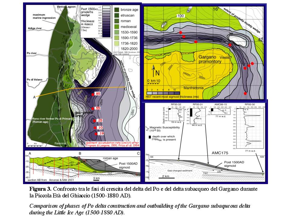
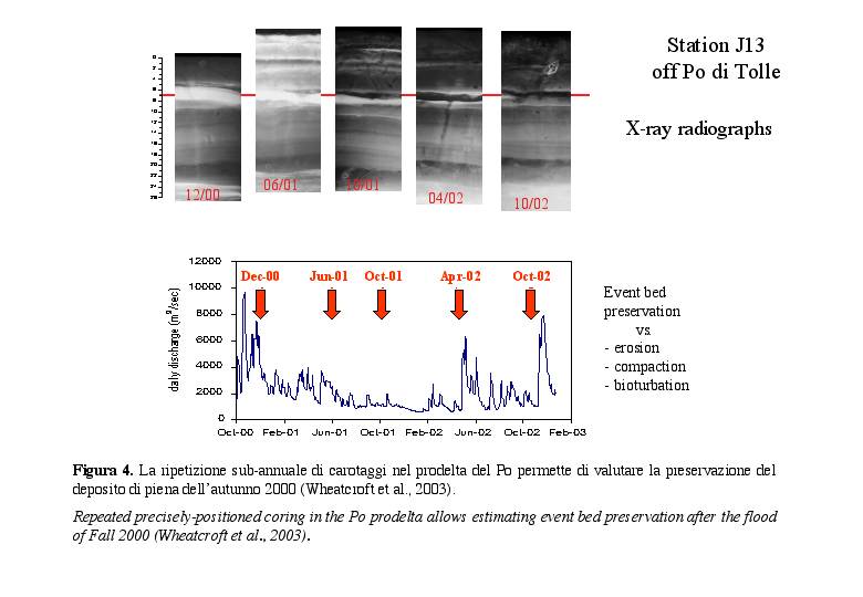
Geophysical imaging of the internal clinoform geometry is integrated with geochronological data on key stratigraphic surfaces (Fig. 3), which allow to compare rates of clinoforms growth over days or seasons (by observing deposition during peak river flood; Fig. 4), decades or centuries (by using short-lived radionuclides as dating tool) and millennia (by using 14C dates and volcanogenic deposits, called tephra).
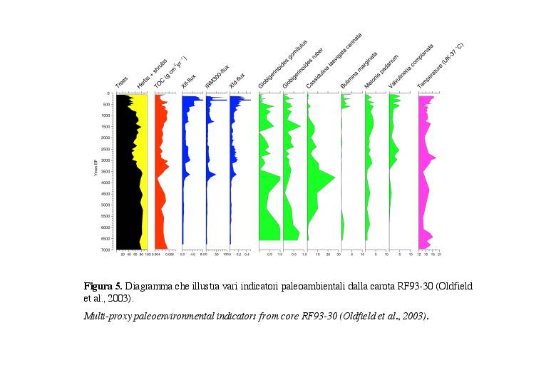
Sediment cores from the clinoform also record changes in land cover and hydrological cycle on land (Fig. 5). Pollen spectra, accompanied by sediment magnetic properties, reveal episodes of forest clearance with increased supply of terrigenous input during the Bronze Age (3600 yr BP) and the Medieval period. These events had a clear impact on benthonic communities.
Support to this international research comes from the EU (projects Eurodelta, coordinated by ISMAR, Promess 1, and Eurostrataform), US ONR (monitoring flood deposits off the Po and Apennine rivers), and Italian SGN (Geological Mapping Program).
Immagini:

