
01/10/2025
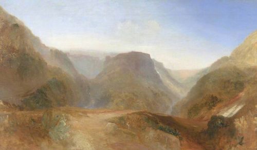
A study conducted by Mauro Bernabei of Cnr-Ibe and Stefano Celletti, director of Parco Marturanum, reveals surprising similarities between the landscape depicted by William Turner in his unfinished painting ‘Italian Landscape’ and that of the Biedano stream, near the Devil’s Bridge in Blera. The discovery, published in the Journal of Cultural Heritage, adds another piece to the map of places that inspired the English painter
A recent study proposes a new and intriguing location for the landscape depicted in William Turner's unfinished painting Italian Landscape, probably Civita di Bagnoregio (1828), housed at Tate Britain in London. The results of the investigation, conducted by Mauro Bernabei, a researcher at the Institute for Bioeconomy of the National Research Council, in collaboration with Stefano Celletti, director of the Marturanum Natural Park in Barbarano Romano (Viterbo), are published in the Journal of Cultural Heritage.
Joseph Mallord William Turner (1775-1851) is considered one of the greatest landscape painters of the Romantic period, known as the “painter of light” for his innovative use of color and for creating rarefied atmospheres that combine reality and dream, anticipating Impressionism and Abstract Art.
Through a comparative analysis between the painting and the actual landscape, the authors identified striking morphological similarities with a stretch of the Biedano stream, near the renowned Devil’s Bridge in Blera (Viterbo), and not with Civita di Bagnoregio or Pitigliano, as previously hypothesized.
“The landscape painted by William Turner had been identified as Civita di Bagnoregio (or perhaps Pitigliano), albeit with some doubt,” explains Mauro Bernabei of the Cnr-Ibe.
Turner visited Italy several times in search of inspiration for light and color. Evidence of his travels can be found in the numerous sketchbooks depicting various Italian cities. In 1828, the year the painting was created, Turner visited Tuscia. His sketchbooks depict views of Viterbo, Nepi, Ronciglione, Montefiascone, and Caprarola, all located not far from Blera. A collection of these sketches can be viewed on the Tate Britain website in London (https://www.tate.org.uk/art/research-publications/jmw-turner/italian-guidebook-sketchbookr1138751#entry-main). It is also known that the Devil’s Bridge in Blera was an important stop for Grand Tour travelers heading to Rome through Tuscia.
“The similarities between the pictorial composition and the real landscape are numerous and detailed: from the W-shaped valleys to the position of the bridge and the path, right down to the perspective adopted by Turner”, explains Mauro Bernabei of the Cnr-Ibe. “Thanks to historical sources, we were able to reconstruct the environment as it was in the early 19th century, confirming the plausibility of our hypothesis. Initially, Turner’s 1828 trip to Italy was virtually retraced; then, a multi-layered approach was used, combining geomorphological observation, analysis of historical images, and correspondence of topographical references” continues the researcher. “The shape and arrangement of the hills depicted in the painting were examined through a comparative geomorphological assessment, which focused on morphological profiles and relative spatial orientation. Historical photographs and ancient cartographic sources were used to trace changes in vegetation cover and settlement patterns over time; this analysis allowed for the reconstruction of the visual environment as it might have appeared in the early 19th century. Key structural elements within the composition, such as the path, the bridge, and their respective positions in relation to natural features, were identified and used as fixed points for matching with real-world locations. Digital overlays were then applied for more precise spatial correlation”.
The Devil’s Bridge, probably dating back to Roman times, is located along the ancient Via Clodia and is immersed in a landscape of great charm, already described with enthusiasm by the English explorer George Dennis in 1842.
“This discovery further enhances the historical and natural heritage of Tuscia,” concludes Stefano Celletti of Parco Marturanum. “It is an extraordinary opportunity to promote the area through art and history and to strengthen the link between landscape and cultural identity”.
The study, which combines art, geography, and technology, opens up new perspectives on Turner's work and his relationship with Italy, particularly with the areas of the province of Viterbo.
Per informazioni:
Mauro Bernabei
CNR - Istituto per la BioEconomia
mauro.bernabei@ibe.cnr.it
Stefano Celletti, director Marturanum Natural Park (VT), cell. 3472272241, e mail: scelletti@regione.lazio.it
Ufficio stampa:
Sandra Fiore
Cnr - Unità Stampa
sandra.fiore@cnr.it
Responsabile Unità Ufficio stampa:
Emanuele Guerrini
emanuele.guerrini@cnr.it
ufficiostampa@cnr.it
06 4993 3383
Vedi anche:
Immagini:


