The scientific results here presented derive from the use of an integrated remote sensing system to monitor the quality of surface water resources, manly linked to ecosystems that are stressed by human impacts and exploitations, such as lakes, estuarine areas, lagoons and coastal zones.
The research started to support the calibration/validation needs of remote sensing observations, with a further development toward the necessity to monitor the eutrophication processes within the routinely observations which often require expeditive missions to face environmental emergencies as:
- algal blooms, including potentially toxic species like cyanobacteria, and mucilages;
- anomalous growth of macrophytes and submerged vegetations;
- discharging of pollutants;
- oil spills.
In all these cases, expeditive interventions become mandatory to reduce impacts as more as possible and to integrate satellite observations for the exact locations of impacting sources. This also gives an unreplaceable synoptic overview, essential to study environmental dynamics in space, hence producing significant information to manage the water-related emergencies, to address solutions and to evaluate results, in particular for small confined spot areas.
The integrated remote sensing system experienced includes the following three items:
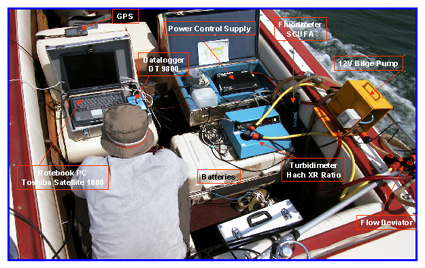
- terrestrial segment consisting with an instrumented prototype called FATA (Fluorescence And Turbidity Analyzer) which, throughout a shipborne hydraulic system, acquires data of physical parameters such as: fluorescence, turbidity and temperature, beyond the coefficients of absorption, attenuation and back-scattering, at a sampling rate of 1-3 Hz.
The flow-through-system operates along surface transects of pelagic and coastal waters to the double aim of getting measurements on water quality and for validation of satellite remote sensing data, improving the traditional measurement methods that usually are point-measurements in the water column. The FATA system is essentially build up with: a water supply system (forced and pumped) whose flow is necessarily synchronized with the boat speed and sampling frequency, a bubble trap to eliminate water turbolence, specific sensors according to the tasks, a data-logger, a GPS, a PC for data storage and visualization, a final outlet;
- a remote segment: the new generation of satellite sensors onboard of Envisat (MERIS), Terra/Aqua (MODIS) and EO-1 (Hyperion), all give useful data to map water quality parameters following physically based approaches. Model performances are evaluated by means of parameters measured along horizontal transects using the FATA system along with hydrological samples (biochemical and physical) in coincidence with the satellite overpasses;
- modelling: FATA measurements and remote sensing information are finally compared with the bio-optical radiative transfer models, either in the water column or at the surface, to produce the final map, analytical and quantitative, of detectable water quality parameters. Among them: chlorophyll and suspended sediment concentrations, Secchi disk depth, surface temperature, all important parameters describing the eutrophication of waters in the 2-spatial domain.
Immagini:


