
16/11/2018
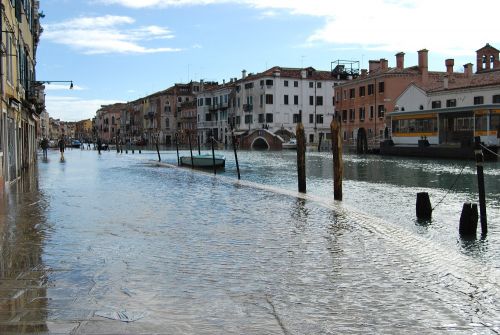
Venice is sinking at a rate of 1-2 mm/y. Combined with the present rate of sea level rise, ~3mm/y, this leads to ever more critical conditions for the possibility of flooding. With half of the city now no more than 80 cm above the present mean sea level and a tidal spring excursion of about 1 metre, any small surge will imply flooding in large parts of the city. A proper and reliable forecast is mandatory.
In stormy conditions the sea level in front of, and hence in, the Venice lagoon is a combination of astronomical (hence well anticipated) tide, and surge and wave conditions following the meteorological situation. In the recent event of 29 October 2018, strong persisting winds blew from the South-East along the Adriatic Sea. This led to a +1.56 m meteorological contribution of the local sea level. It was only the lucky condition that this maximum was reached during the astronomical minimum, that avoided a more tragic disaster – potentially the worst in documented history. This would have happened had the peak of the storm taken place a few hours earlier or later.
The official tidal forecast in Venice is issued by the Centro Previsioni e Segnalazioni Maree (Tidal Forecast and Warning Centre) of the local town council. The physical and modelling expertise is mostly provided by the Institute of Marine Science, the Venice branch of the Italian National Research Council. The basic, but not unique, meteorological information is the forecast issued by the European Centre for Medium-Range Weather Forecasts (ECMWF), used for the tide in the whole Mediterranean basin, and for waves in the Adriatic Sea (for waves, the narrow Otranto strait at its southern end makes the overall Mediterranean influence negligible for Venice). For the tide, atmospheric pressure and surface wind are the relevant information; the latter of which is used for waves. Due to a slight, but non-negligible, underestimation of the surface wind speeds when blowing off-land, a carefully validated wind speed enhancement factor is applied to the forecasts in the Adriatic Sea. This is estimated for any new ECMWF forecast resolution implementation, comparing the previous and new models, and measured wind and wave data. The present enhancement factor applied to the ECMWF wind forecasts is 1.16.
The tidal model considers both the new meteorological contribution and the oscillations (seiches) of the basin following previous events. The wave information, granted its obvious interest, is also relevant for the coastal sea level following the accumulation of water towards the coast, due to the breaking of the large waves during their approach to the coastline in progressively less deep conditions.
The operational wave forecast for the 29th October 2018, estimated using the ECMWF wave field (WAM model). The white area shows wave heights that exceed the usual scale of the forecasts.
It is worth stressing how critical the meteorological forecast is. Both the sea level and the wave height depend on a power (2 or more) of the surface wind speed. Therefore any small error, in time, position and intensity, of the driving fields leads to substantial errors in the forecast of interest to the city. In the recent event on 29th October 2018, the basic information that a major storm and tidal event were on their way was available five days in advance of its occurrence. This was essential in preparing, within limits, the city to face the situation.
Per informazioni:
Luigi Cavaleri
Cnr-Ismar
luigi.cavaleri@ismar.cnr.it
Immagini:


